
Trapster® users share the location of police speed traps just by interacting with their mobile phones. The system uses the phone's GPS capabilities and wireless location, voice transcription, geocoding, reverse geocoding, and SMS, with a central database server. It communicates in real time, using the Internet to instantly alert other users as they approach the reported trap.
The Trapster® software and service is totally free and you can signup on there website for a free account and download this great piece of software.
Free Download: tms.jad and tmu.jad
Showing posts with label traffic. Show all posts
Showing posts with label traffic. Show all posts
Monday, October 20, 2008
No need to flash your high beams - just use you Trapster

Monday, September 04, 2006
Mobile Phones ued for Traffic Jam Detection
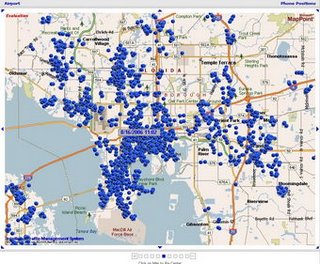
IntelliOne has developed a system- 'the TrafficAid system'- taking anonymous mobile phone location information and turning it into an illuminated traffic map that identifies congestion in real time.
The system takes advantage of the steady stream of positioning cues--untraced signals all cell phones produce, whether in use or not, as they seek towers with the strongest signals. It is the first traffic-solution technology that monitors patterns on rural roads and city streets as easily as on highways.
Unlike sensors and other equipment along major freeways that is expensive and takes years to deploy, our system takes advantage of existing cellular networks in which wireless carriers have already invested billions of dollars," said National Science Foundation (NSF) awardee and IntelliOne CEO Ron Herman
Thursday, July 27, 2006
Google live traffic Maps on your Mobile Phone
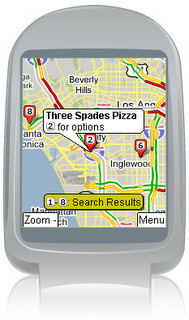
Google has integrated a live traffic feed into its Google Maps for Mobiles application. The service allows you to choose a destination and have Google map out the route for you, and by selecting show traffic “highway traffic information is sent to the phone, with road conditions highlighted in three colors: — red for congested, yellow or orange for slowdowns, and green for smooth sailing”. It’s in “30 major US cities”, including LA, New York and Chicago.
Subscribe to:
Posts (Atom)

 Posts
Posts


